New Data Shows Subsidence Continued in Water Year 2021, But Pace Slower than Seen in Previous Droughts

The California Department of Water Resources (DWR) released new satellite-based data that show subsidence – or the sinking of the land surface due to excessive groundwater pumping – continues in the state. DWR has intensified statewide subsidence monitoring to help identify impacts and address them collaboratively with local groundwater agencies, counties and landowners.

The areas experiencing the most subsidence during Water Year 2021 (WY 2021) are in the San Joaquin Valley, with a maximum of 1.1 feet of subsidence observed in the region and the Sacramento Valley with a maximum of 0.7 feet in the region. Data show that in WY 2021 subsidence of greater than 0.5 feet per year expanded to more areas than observed in WY 2020. However, fewer areas experienced higher rates of subsidence than at the end of the last drought in 2016.

Click here to read more from DWR News.

Sacramento Valley Watersheds: Regional Collaborative Approaches to Maintaining and Improving Groundwater Quality for Multiple Benefits

Vicki Kretsinger Grabert writes,

“Understanding the status of California’s surface water and groundwater availability and sustainability are key goals of many programs. Sacramento Valley’s water resources managers and communities are proactively and collaboratively engaged in identifying and implementing strategies that support water resources sustainability. This includes protecting groundwater quality for multiple beneficial uses, which is being addressed through the following programs … ”

Read more from the NCWA blog here:  Sacramento Valley Watersheds: Regional Collaborative Approaches to Maintaining and Improving Groundwater Quality for Multiple Benefits

How does SGMA affect Glenn County?

“A California law that passed in 2014 gave local control to agencies to manage their groundwater.  The Glenn Groundwater Authority – created in 2017 – is an agency that was formed under the Sustainable Groundwater Management Act to regulate groundwater at a local level.

“The last thing anybody wants is more regulation, I get that,” said Dave Ceppos, program manager for SGMA, during a public workshop on the law on Thursday. “… What SGMA did was gave over a huge amount of local control.” … ”

Read more from the Glenn County Transcript here:  How does SGMA affect Glenn County?

Survey Shows Areas of Land Subsidence in the Sacramento Valley

Data shows most of the valley has experienced little to no subsidence over the past nine years, with some exceptions

From the Department of Water Resources:

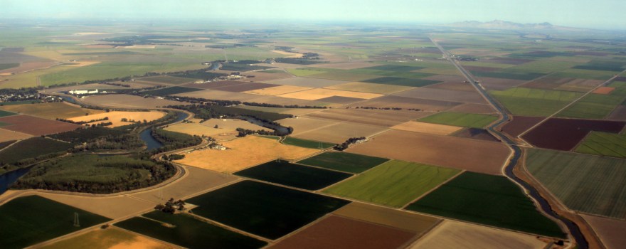
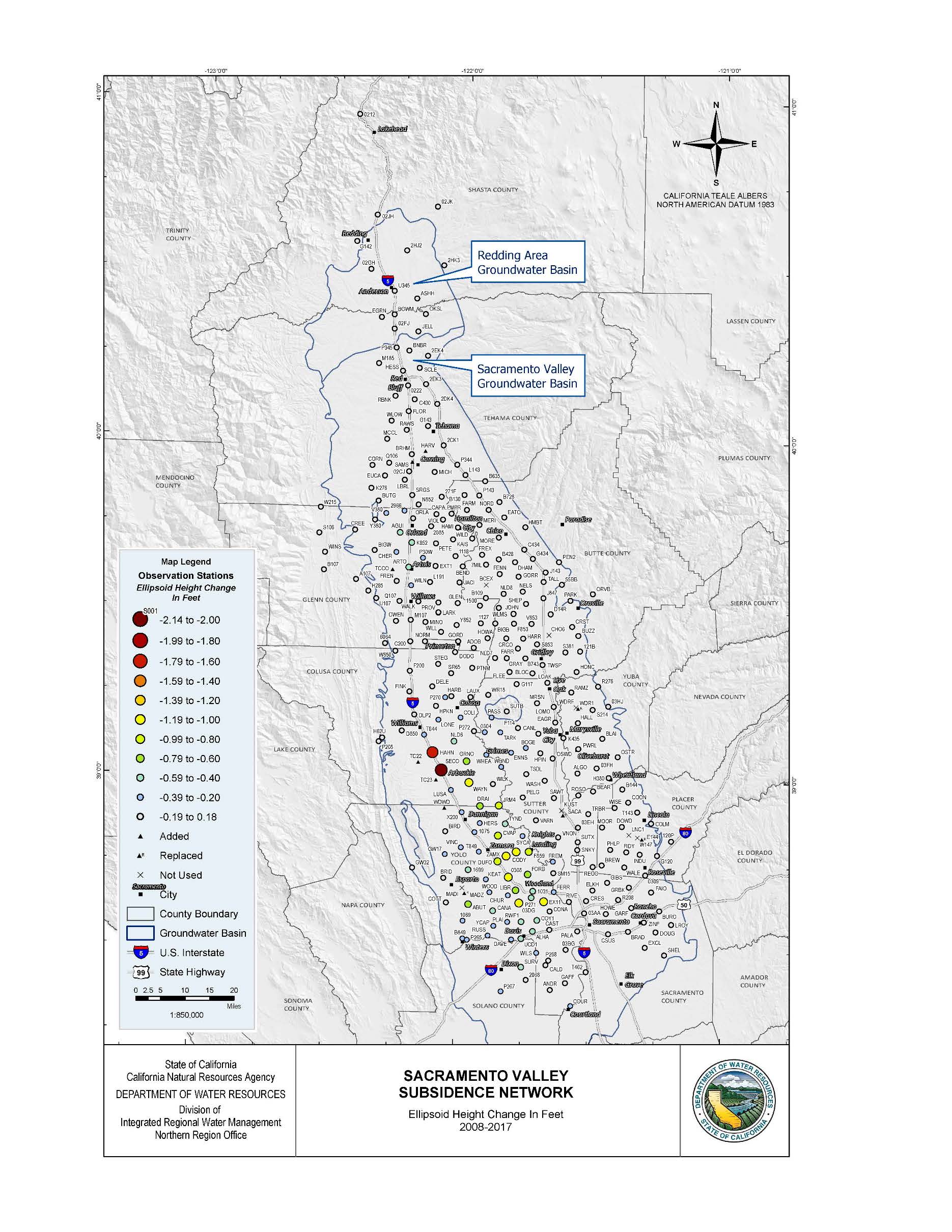
New data released today measure changes in land subsidence in the Sacramento Valley over the past nine years, finding the greatest land surface declines near the city of Arbuckle in Colusa County. According to the Sacramento Valley GPS Subsidence Network Report and accompanying fact sheet, most of the valley has experienced little to no subsidence, however, land in the Arbuckle area has sunk 2.14 feet compared with baseline measurements recorded in the same location in 2008. The report was led by the California Department of Water Resources (DWR), in coordination with 19 state and local agencies.

“We’ve long known that excessive groundwater pumping causes subsidence, which is one of the many reasons we’ve pushed for sustainable groundwater management and pursued innovative tools to better manage and report subsidence throughout the state,” said DWR Director Karla Nemeth. “Data provided by studies like this inform water managers and owners of large infrastructure so they can plan for and prevent against subsidence.”

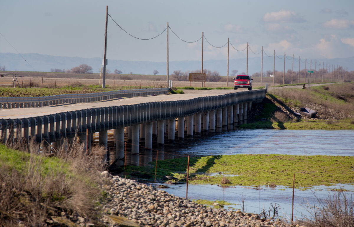
Land subsidence can damage critical infrastructure, including water delivery systems, levees, roads, and bridges. In 2017, DWR worked with NASA to release a report on San Joaquin Valley subsidence citing areas along the California Aqueduct that have experienced almost two feet of subsidence over three years.

The Sacramento Valley survey results were collected as groundwater levels were recovering from the severe drought of 2012-16, which saw groundwater levels in much of the state reach historic lows. Compared with 2011 pre-drought groundwater levels, the largest decreases were observed in Glenn and Colusa counties at 58 to 43 feet, respectively. Field work indicates that groundwater levels have recovered an average of seven feet, but more frequent and more comprehensive monitoring is needed to more accurately detail the impacts of droughts and high-water years on groundwater levels and subsidence.

The Sacramento Valley GPS Subsidence Monitoring Network, launched by DWR in 2008, surveyed 300 measurement locations in 11 counties from Shasta County in the north to Solano and Sacramento counties in the south. The 2017 resurvey effort was led by DWR’s Division of Integrated Regional Water Management (DIRWM) Northern Region Office (NRO), with the assistance of 19 state, county, and local entities.

“The data provided in this report are an example of the technical assistance we provide and the collaborative effort needed to facilitate successful and sustainable groundwater plans at the local level,” said Taryn Ravazzini, DWR Deputy Director of Special Initiatives.

DWR offers several tools that assist groundwater agencies and the public assess aquifer conditions and plan for sustainable management, including:

  • Land Use Viewer: Allows local agencies and the public to access land use survey datasets for the past 30 years.
  • Well Completion Report Viewer: Provides information about wells collected during the drilling and construction of water wells.
  • SGMA Data Viewer: Compiles many groundwater related datasets that can be used to look at groundwater levels and subsidence.

The Sacramento Valley subsidence report also concludes that areas of Yolo County experienced the most widespread subsidence, in terms of geographic area affected by subsidence, with 31 survey sites measuring a land surface decline between .3 and 1.1 feet. Other statistically significant levels of subsidence were observed at three survey sites in Glenn County (between .44 and .59 feet of subsidence) and five survey sites in Sutter County (between .20 and .36 feet of subsidence).

Vignettes on Local Groundwater Management in the Sacramento Valley

The NorCal Water Association blog writes,

“Local leaders on the Sacramento Valley floor are well organized and coordinated with respect to groundwater management and the efforts to implement the Sustainable Groundwater Management Act (SGMA). Local Groundwater Sustainability Agencies (GSAs) are all working hard to manage groundwater in a sustainable manner with a focus on completing the initial Groundwater Sustainability Plans (GSPs) by January 2022.

With the emphasis on local agency implementation of SGMA, we have asked many of the local leaders to provide their perspective on local groundwater conditions and the management necessary to manage water resources in a sustainable manner. … “

Continue reading at the Northern California Water Association blog here:  Vignettes on Local Groundwater Management in the Sacramento Valley

Butte County: Helicopter survey should aid groundwater planning

From the Oroville Mercury Register:

“Butte County may soon have a better idea of what lies beneath its surface, thanks in part to the Kingdom of Denmark.  Starting in late November, a helicopter took off for several days from the Orland airport to fly a pattern over an area between Chico and Orland, and southeast into Butte Valley.  Dangling beneath the helicopter was a hoop loaded with devices that created a weak magnetic field and instruments that measured how that interacted with layers beneath the soil.

Christina Buck with the Butte County Department of Water and Resource Conservation explained that underground there are layers of sands and gravels that hold water, divided by layers of clay and silt that block water passage to different degrees. … ”

Read more from the Oroville Mercury-Register here:  Butte County: Helicopter survey should aid groundwater planning

Camp Fire effect on groundwater, wildlife still uncertain

From the Daily Democrat:

“The immediate, physical impact of the Camp Fire is plainly obvious to anyone who lost one of the nearly 14,000 homes in the blaze, or who sees the blistered remains of buildings that once made up the town of Paradise.

But less immediately visible are the scars wildfire can inflict on the local environment, including surface water, groundwater and the wildlife population. … “

Read more from the Daily Democrat here:  Camp Fire effect on groundwater, wildlife still uncertain

Public workshop to discuss sustainable groundwater management in Sierra Valley

From Plumas County News:

“The public will have an opportunity to learn about local implementation of the Sustainable Groundwater Management Act (SGMA) in the Sierra Valley Basin at a workshop Thursday, Oct. 25, from 6 to 8 p.m., at Sierra Christian Church, 81059 Highway 70, in Beckwourth. … “

Continue reading at Plumas County News here:  Public workshop to discuss sustainable groundwater management in Sierra Valley

Streamflow availability ratings identify surface water sources for groundwater recharge in the Central Valley

From California Agriculture:

“In California’s semi-arid climate, replenishment of groundwater aquifers relies on precipitation and runoff during the winter season. However, climate projections suggest more frequent droughts and fewer years with above-normal precipitation, which may increase demand on groundwater resources and the need to recharge groundwater basins. Using historical daily streamflow data, we developed a spatial index and rating system of high-magnitude streamflow availability for groundwater recharge, STARR, in the Central Valley.

We found that watersheds with excellent and good availability of excess surface water are primarily in the Sacramento River Basin and northern San Joaquin Valley. STARR is available as a web tool and can guide water managers on where and when excess surface water is available and, with other web tools, help sustainable groundwater agencies develop plans to balance water demand and aquifer recharge. However, infrastructure is needed to transport the water, and also changes to the current legal restrictions on use of such water. … “

Continue reading from California Agriculture here:  Streamflow availability ratings identify surface water sources for groundwater recharge in the Central Valley

Butte County: Comment taken on groundwater management area boundaries

From the Chico Enterprise-Record:

“Comment is being taken on proposed boundary changes related to the managing of groundwater beneath Butte County.

The Sustainable Groundwater Management Act requires development of plans to manage groundwater beneath California to avoid undesirable results like land sinking or wells going dry.  The plans are required for defined subbasins of the larger aquifers underground.

The Butte County Department of Water and Resource Conservation has applied to change the subbasin boundaries locally in response to requests by involved agencies, and that’s what the public is being invited to comment upon. …. “

Read more from the Chico Enterprise-Record here:  Comment taken on groundwater management area boundaries